|
Introduction
Boston underwent a series of topographical, political, economic, and social changes that continue to shape its role and appearance as a leading metropolis in the world. Ever since the coast of New England was explored in the early 17th century, the region, and in particular Boston, was deeply transformed. The most significant changes that have been documented and can be correlated with social changes occurred at the start of the 19th century. Since the United States government began to collect census data in 17901, this paper will focus on changes that occurred from that period onwards. The Christian Science Center has its own history of change within the context of Boston’s growth. In order to gain a better understanding of how the Christian Science Center became what it is today, a landmark and a main tourist attraction, its attributes over time will be examined individually and then correlated with the changes that occurred in Boston for changes in particular places in cities can only be truly understood when analyzed within the context of change within cities themselves.
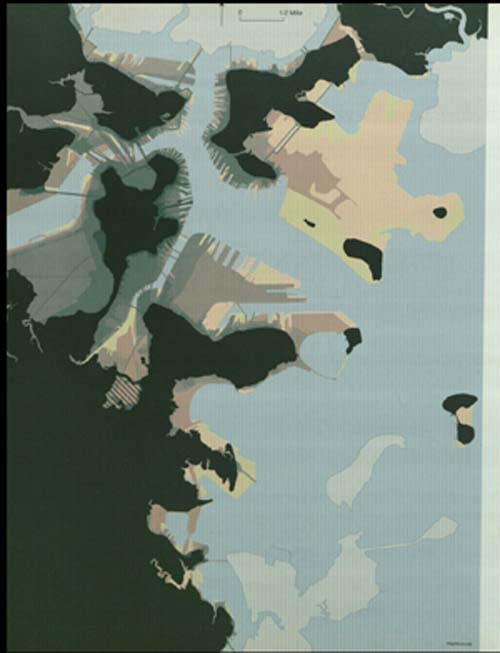
Composite map of landmaking projects which graphically illustrates the growth of Boston's
land area and change in its shoreline since 1630. The original land of 1630 is marked in
dark green. The brighter the colors become, the more recent the development is. Land that
was added after 1995 is shown in bright yellow.
Source: Mapping Boston, page118
Timeline Overview and Its Implications: Christian Science Center
Mary Baker Eddy, the famous author and teacher of the second half of the 19th century, is the founder of Christian Science and the First Church of Christ, Scientist. In 1866, Mary Baker (at the time) suffered a severe injury after falling on ice and was bed-ridden for months. In her personal attempt to find recovery, she picked up the Bible and searched for answers. In the process, she discovered what she later referred to as Christian Science: a form of Christianity that is based on the scientific belief in spiritual and moral healing through laws relating to the nature of god and his creation based on stories of Jesus’ healing method which did not rely on drugs, hygiene, or medicine2. And so after a struggle to seek acceptance for her beliefs by fellow Christians, Mary Baker Eddy founded the original church of Christ in 1894. In 1906, the small gray-stoned structure was dwarfed by a domed extension that can still be seen today from the opposite side of the Charles River. Mary Baker Eddy also established the Christian Science Publishing Society which built the Mary Baker Eddy Library in 1934 after Mary’s death, where her writings and books are held and some are still in print. At that point in history the Christian Science Center was a landmark in Boston, yet it did not become a famous tourist attraction until after the 1960s when the Christian Science Center Plaza was constructed. The plaza is home to the Reflecting Pool and the Splash Fountain which operate between the months of April and November and attract residents and tourists alike for their relaxation and entertainment value. Before Mary Baker Eddy embarked on her mission to popularize Christian Science, the site was used for other purposes, far from institutional. These events will first be stated and their implications later interpreted.
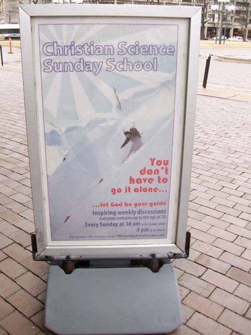
Advertisement for Sunday school at the Christian Science Center.
Photograph taken by author.
|
In 1887, the site was mostly composed of a large empty area, a couple of flats on Huntington Avenue, and several apartment houses and French Flats being built. In comparing the site in 1887 to its current appearance, one might think that both sites are not really the same place. In fact, comparing the site at any period of time before the 1960s to its current appearance, it is difficult to predict the patterns of development, for there were several. Not only are the buildings present at the time not at all in existence today, but even the streets that cut through the site as well as the street names are also entirely different, with the exceptions being Huntington Avenue, Belvidere Street, and Dalton Street.
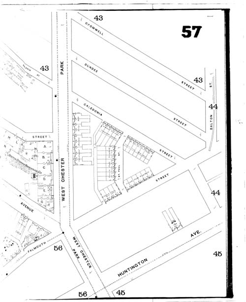
1887 Sanborn fire insurance map showing the planned rows of French Flats and apartments.
Source: MIT Libraries online catalogue
In 1897, the large empty spaces were quickly filled with the more apartments and flats than had been initially proposed a decade earlier. The central triangle which is the most noticeable area on site went from being almost entirely empty to overly congested. By then the original First Church of Christ, Scientist had been built (1894) as well as the Hotel Brookline, which was another central landmark of that piece of land. The flats on Huntington Avenue also increased in number although there were no previous plans of construction, indicating that development was booming in that area. The rest of the area was occupied with city tenants, there were flats everywhere. The streets by then had also changed their names. The construction of the Harvard Bridge was completed and so West Chester Avenue was renamed Massachusetts Avenue, and Caledonia Street became Norway Street. Even if one looks outside the borders of the site at St. Botolph Street which lies parallel and south of Huntington Avenue, one cannot ignore the density of the flats and high rate by which they spread throughout the general area. The late 19th-early 20th century was certainly a time of fast-paced development. On a basic level however, the site was still a small gray-stoned building, a church with unorthodox ideas that clearly lacked the support of the general public, and rows of flats. Those who visited the site at the time were strictly either a part of the church’s congregation, or residents of the apartments.
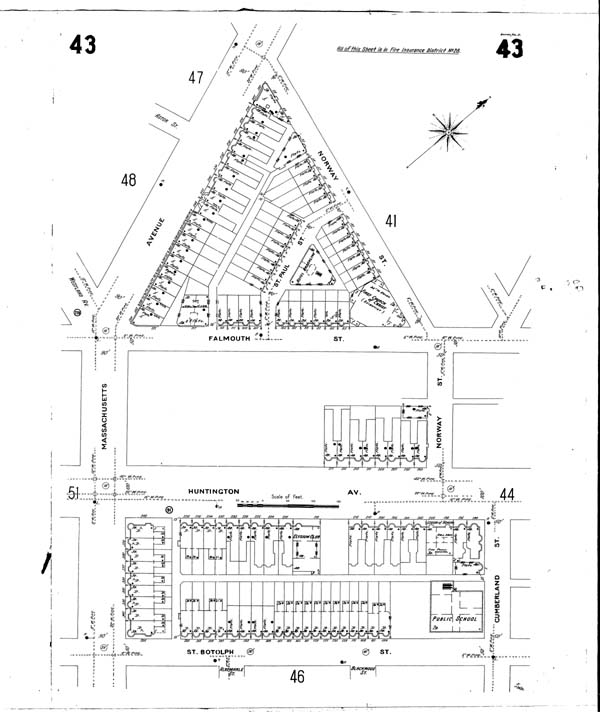
1897 Sanborn fire insurance map showing the dense housing development on site and the construction of
the original church and the Hotel Brookline.
Source:
MIT Libraries online catalogue
In 1914, big changes occurred on site. First of all, one can immediately notice the sharp decrease in the number of flats overall. The area still looks dense and filled with structures; however the majority of the flats as well as the Hotel Brookline were replaced with the original church’s extension, a massive dome structure that took up lots of space. Another row of flats was replaced with the Christian Science Administrative Office building, and there was a new bakery between the flats, business which, along with the domed extension would attract more visitors to the site. A new street was also constructed, St. Paul Street, which served to connect Falmouth Street to Norway Street, thereby further isolating the original church and its extension from the rest of the site. On the block that lay on Huntington Avenue, there were no changes to the number of flats or apartments, however two newly constructed buildings were added, the St. James Theater in 1911 which included a restaurant and a large exhibition hall, the Massachusetts Horticultural Hall (built 1901). The hall’s opening lasted for 10 days and exhibited a wide array of flowers and ornamental plants. The building was later renovated in 1984 and officially became a part of the Christian Science Center Plaza when it was sold to the Christian Science Society in 1992. The rest of the space was filled with a large central park which most probably provided a good scenic attraction for those who visited the site’s landmarks. It is fair to assume that more people frequented the site, not just for worship. At a time when the population of Boston was multiplying at a soaring rate, the building of an extension of such a grand caliber gave the people another scene in the city to enjoy. It is entirely plausible to assume that when a new building is constructed, in most places, those who pass by will take a brief moment to stop and examine it on the outside. The more people there are, the higher the chance that they will enter that building and explore its interior.
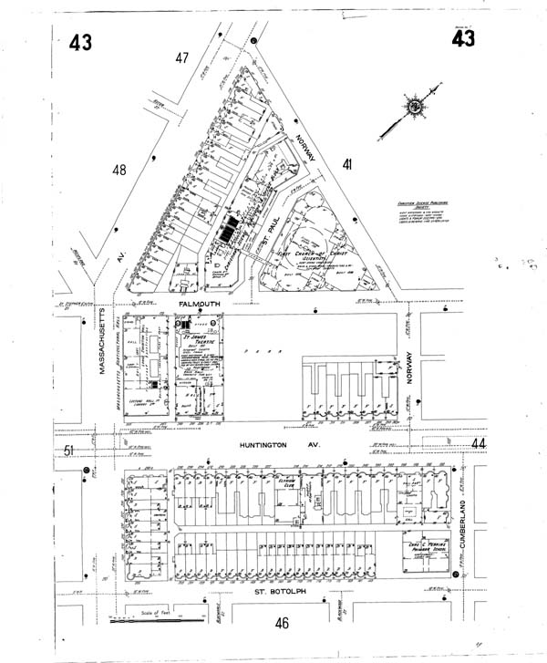
1914 Sanborn fire insurance map showing the newly constructed theater and horticultural hall, as well as the
domed extension, administrative offices, and many more flats and apartments.
Source: MIT Libraries online catalogue
In 1937, the density of the area further increased with the construction of the Christian Science Publishing Society and the Mary Baker Eddy Library (built 1932-1934) along Norway Street. Four rows of flat and apartments were added on Clearway Street, St. Germain Street, and Belvidere Street. Crowded between the rows of flats was the New England Telephone and Telegraph Company (built 1913) which was one of earliest companies to specialize in telecommunications in the region, reinforcing once again the notion of an entrepreneurial city. By this time all the streets had all been renamed to their present names. All of these new buildings brought in more people to the site. The publishing society and telephone company created new jobs of all kind and so drew in employees and customers at the same time. The library was an eleven storey building, the tallest building on site and in the surrounding area at the time, a large enough structure to excite the casual passerby and especially the regular visitors of the Boston Public Library which is located not too far away from the Mary Baker Eddy Library.
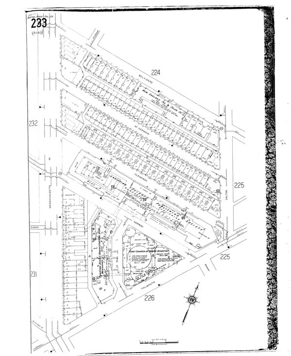
1937 Sanborn fire insurance map showing the publishing society, the telephone company, St. Paul Street,
and the flats and apartments.
Source: MIT Libraries online catalogue
Almost three decades later, the site went through more changes in the 1960s, many of which can still be seen today. The flats along Massachusetts Avenue as well as the Christian Science Administrative Offices were demolished in order to bring in more investment in the 1960s. They were replaced with I.M. Pei’s Reflecting Pool and Splash Fountain, hence destroying St. Paul Street in the process in an attempt to reconnect the Church with the rest of the site to create an image of a plaza. Yet the rows of flats along Clearway Street and St. Germain Street as well as Falmouth Street remained on site until after the year 1990 indicating the long-standing resistance of cities to motivate its residents to move out into the suburbs. When these flats were later demolished, Falmouth Street was destroyed and so the connected parts of the plaza grew larger and the developers were able to place benches and ledges all around without facing opposition from residents who might have been apprehensive about having their “neighborhood” filled with visitors all day long.
Consequently, the creation of the plaza which included the pool, fountain, and continuous growing of grass, trees, and other greenery on site, as well as the addition of benches, ledges, and other designated seating areas was the final major event that resulted in the current influx of visitors to the site on a daily basis. Even in the winter, on days of moderate coldness, people can be seen walking along the plaza: businessmen during their lunch breaks, students cutting through, parents strolling their children,… People no longer visit the plaza strictly to worship anymore as was the case when the original church was built. It is now a place to enjoy a walk on a nice day outside, to clear one’s mind, to converse with a friend, and most importantly, to perform people’s favorite public activity: to watch other people. Another byproduct of the development of land use at the Christian Science Center was the advancement of education. The church hosts weekly Sunday school sessions in which people can learn more about Christian Science and lessons from the Bible3. The establishment of a library also contributed to the overall improving standard of education that Boston became renowned for. As can be inferred, the changes that have occurred at the Christian Science Center since the late 19th century have affected it largely on a social level.
The history of the site only tells part of the story however: what happened over time. In order to fully understand how these changes occurred and why, one must take a step back and examine the site within the context of the changes that occurred in the Boston area at around the same period of time. The parallelism between the two will help establish the full concept of change specific to the Christian Science Center, what it was, how it happened, why it occurred in the first place, and what its short and long term consequences were. Since most of the changes that took place at the site were related to land use from a social perspective, the same aspects will be examined in Boston regarding the overall population and significant changes in the city itself.
Timeline Overview: Boston
As stated in previous assignments, modern day Boston was essentially “under water”. The neighborhoods that surround the site directly, the Back Bay and the South End, were built on filled land during the mid-1800s4. As a result, the population of Boston multiplied immensely after the expansion of land in the 19th century. In examining population density maps from 1790 until the current day, a significant increase in density occurs after 1860 when a large percentage of the land was built that could accommodate the floods of immigrants arriving from other parts of the world, mostly Europe. Before the land was completely filled in the first half of the 19th century, the population of Boston was around 60,000. In 1850, the population rose to 137,000 of which 46% were foreign-born, a strong indication of the high rate of immigration. By the year 1900, the population rose to over half a million at 550,0005.
The distribution of people in terms of population density did not increase linearly however. The Great Boston fire of 1872 created a fear amongst the people from the evils of the city and the dangers of living within such close proximity to one another and to commercial businesses, railroad track construction, and industry. The city government also lacked the support it needed to reassemble the city on a financial, political, and public level. Hence a shift in population density can be seen after the fire in which more people moved out to the neighboring suburbs6. The Depression of the 1920s resulted in a decrease in population growth, especially within the city. The suburbs were once again popular then due to lower land prices. The population of Boston continued to increase however until the 1950s (801,000) after which it suffered a decline in the 1960s to 697,000 people after the West End and Scollay Square were razed under urban renewal programs and people were forced out of the city. Currently, the population of Boston is over 620,000 and the city attracts over 18 million visitors every year7.
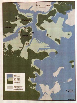 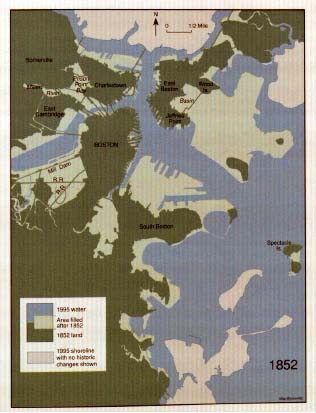
Maps showing land growth in Boston in 1795 and 1852. The green area represents land at the dated year, the white area represents land filled after the dated year, and the blue area represents water.
Source: Mapping Boston, page 16-17

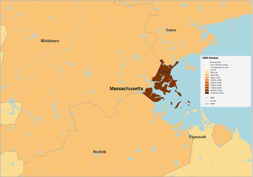
Map representing Boston's population density (per square mile), taken from the 1800 census.
The
more dense the area is, the darker its color. The highest population density at the time
was 1,000 to 2,635 people per square mile.
Map source: http://www.socialexplorer.com/pub/maps/map3.aspx?g=0&mapi=2000%20Census%20Tract&themei=1
Map representing the population density in Boston in 1860. The maximum density at the time
was 15,000 to 35,440
people per square mile.
Map source:
http://www.socialexplorer.com/pub/maps/map3.aspx?g=0&mapi=2000%20Census%20Tract&themei=1
|
Boston and Christian Science: the relationship
So far the focus has been on the relationship between land use and population changes, whether on the small scale of the Christian Science Center, or on the large scale of the city of Boston. General factors that influenced the abovementioned changes in population can be attributed to geography, academics, politics, economy, and technology. Such factors in turn played a significant role in defining the development of the Christian Science Center and the changes that occurred in its use and status in society.
Geography
Boston is a coastal city and as a result of its location, it has always been one of the first cities to be accessed by foreigners, whether explorers, colonizers, traders, travelers, or immigrants. Its location has given it over the years the great advantage of being a primary landing spot, despite its small area. Hence, when the Irish, Italians, Germans, French, Russians, Arabs, and Jews migrated to the United States in the 19th century, the Boston Harbor was one of the first to welcome them. The construction of flats and apartments of such a high density helped accommodate the flood of immigrants. The immigrants who by the end of the 19th century constituted a large percentage of the population were mostly of Catholic and Protestant faiths. The rejection that Mary Baker Eddy faced towards her newfound faith in Christian Science was understandable at the time. Her pursuit of establishing her own Church is also understandable, considering that due to Boston’s location, there was a real chance in spreading Christian Science outside the borders of the city, perhaps even to the rest of the world. Mary Baker Eddy’s vision in that case was entirely within the scope of reason, considering how quickly Boston’s reputation was growing in Europe and the rest of the world. The establishment of the Christian Science Publishing Society is further confirmation of this attitude of reaching out to the people outside of Boston.
Academics
Several academic institutions flourished in Boston after the land reclamation efforts of the 19th century. Institutions such as the Massachusetts Institute of Technology (est. 1861), Boston College (est. 1863), Boston University (est. 1871 in Boston as the Boston University School of Theology), Northeastern University (est. 1898), the Berklee College of Music (est. 1945), and several others contributed in attracting intellectuals to Boston8. Such changes in social composition enabled Christian Science to grow as an institution of its own, since the increase in the number of intellectuals and students meant less public resistance to the Church’s unconventional ideas and a higher level of interest in the other amenities that it later provided such as the library and the Sunday school.
Politics
The late 19th century was a sensitive time in the history of the United States. Following the American Civil War, the country was still recovering from the damages created by a politically divided country. The late 1800s was also a significant time in the civil rights movement, and in particular women’s rights. At the time women were still not allowed to vote and faced segregation on issues of work and property ownership. Despite facing rejection from the public, Mary Baker Eddy continued to push forward her ideas. Her persistence eventually granted her approval to build the original Church. Whether that was a genuine attempt on behalf of the city government to advance the rights of women, or an attempt at making it seem like that was case in order to advance its own status and reputation locally and internationally, is difficult to tell. Regardless of intentions however, it succeeded in establishing both. One the one hand, it was a positive step in the advancement of civil rights and the rights of women. On the other, it marked the beginning of the “liberal” attitude that Boston would later become renowned for. It also gave the city the opportunity to take advantage of the potential success of such a project. If Christian Science could truly attract the attention of the world, then Boston would become known as the pioneer in a certain field which would no doubt bring it reputation and status.
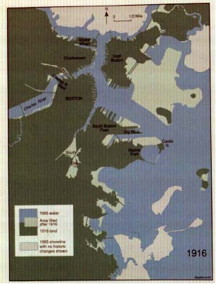 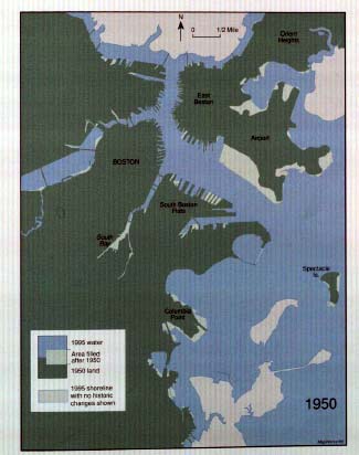
Maps showing land growth in Boston in 1916 and 1950. The green area represents land at the dated year, the white area represents land filled after the dated year, and the blue area represents water.
Source: Mapping Boston, page 18-19
Economy
The growing population of Boston attracted businesses of all sorts. The commercial boom that occurred in the 20th century saw the development of several businesses close to the Christian Science Center. The Prudential Tower (1964), the Hilton and Sheraton hotels, and the development of Newbury Street (1970s) are a few examples of major commercial events that enhanced the city’s economy and attracted visitors. Such changes inspired the development of the plaza in which the expansion allowed the site to participate in this growing economy and provide another tourist attraction spot. Within the plaza itself, developers from early-on realized the importance of business in attracting non-residents, and so the small bakeries and restaurants, the administrative offices, the theater, the horticultural hall, the hotel, and the telephone company were all attempts at mixed land-use, commercial, institutional, and residential, that would help the site flourish. Even after the Christian Science Society took over the entire plaza, it still runs offices and businesses within the scope of Christian Science, such as the Sunday school.
Technology
Discussing change through technology is a broad topic particularly because technology can be viewed as responsible for driving the other factors mentioned above. In Boston, and especially at the Christian Science Center, technology was responsible for the Reflecting Pool and Splash Fountain which formed the plaza that established the Christian Science Center as a city landmark. In looking at the bigger picture, technology was responsible for developing the modern sewer system in 1878 in Boston which essentially allowed buildings the size of the domed extension and the library to function properly. Technology also advanced transportation: the Christian Science Center was first accessible by automobile, then by the railroad, and eventually by subway systems, buses, and airplanes! In essence, Technology allowed Christian Science to reach the peak of its popularity; it is the main enabler in realizing the vision of Mary Baker Eddy.
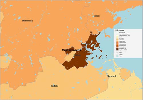
Map representing the population density in Boston in 1900. The maximum density at the time
was 15,000 to 47,727
people per square mile.
Map source:
http://www.socialexplorer.com/pub/maps/map3.aspx?g=0&mapi=2000%20Census%20Tract&themei=1
Map representing the population density in Boston in 1950. The maximum density at the time
was 15,000 to 254,686
people per square mile.
Map source:
http://www.socialexplorer.com/pub/maps/map3.aspx?g=0&mapi=2000%20Census%20Tract&themei=1
Conclusion
In conclusion, the changes that occurred at the Christian Science Center cannot be treated separately from those that took place in Boston even before the establishment of Christian Science. The correlation between the two highlights the importance of history in understanding the current state of affairs and predicting future patterns of change. The past, present, and future are interlocked in a large network of cause and effect that is influenced by external factors, some of which occur by chance, others due to the persistence and vision of certain individuals. When Mary Baker Eddy built the original Church, did she think it would become a landmark city attraction? Perhaps not. Yet it does not change that fact that if it weren’t for her strong beliefs in her cause, Boston might have not been the world’s headquarters of Christian Science. Places within cities are in a continuous process of change. It is only by examining change from a bigger perspective can its details be fully understood and the characters of cities better appreciated.

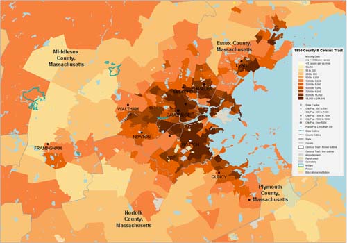
Map representing the population density in Boston in 1900. The maximum density at the time
was 15,000 to 229,783
people per square mile.
Map source:
http://www.socialexplorer.com/pub/maps/map3.aspx?g=0&mapi=2000%20Census%20Tract&themei=1
|
Sources:
- http://en.wikipedia.org/wiki/United_States_Census
- http://christianscience.com/questions/about-christian-science/
- http://christianscience.com/church/youth-activities/
- Mapping Boston, Sam Bass Warner, Jr. A Brief History of Boston page 2-14
- Mapping Boston, A Boston Chronology, page 243-246
- Kenneth Jackson, Crabgrass Frontier: The Suburbanization of the United States
- http://www.bostonusa.com/partner/press/pr/statistics
- (Dates taken from the websites of the listed universities)
|
|
|
|
|
|